3. Overall Approach
The policies in this chapter set out an overall approach for the growth and regeneration of the borough, to build a strong economy and deliver economic, social and environmental benefits. The first policy sets out the core approach of building a strong economy whilst improving quality of life. The second policy outlines broadly how much and what type of development is appropriate in each settlement, with other policies explaining how the two key environmental issues of protecting the countryside and managing flood risk will be addressed.
Policy CS1 – Quality of Life
As a means to securing and improving economic prosperity, enhancing the quality of place, and the quality of life in Doncaster, proposals will be supported which contribute to the Core Strategy objectives, and in particular:
A) Provide opportunity for people to get jobs, learn new skills, and have access to good quality housing, local services, sport, leisure, religious and cultural facilities.
B) Strengthen communities and enhance their well-being by providing a benefit to the area in which they are located, and ensuring healthy, safe places where existing amenities are protected.
C) Are place-specific in their design and which work with their surroundings protecting and enhancing the built and natural environment, including green spaces, buildings, heritage assets, trees, waterways and public spaces.
D) Are accessible by a range of transport modes which offer choice, and are open and inclusive to all.
E) Protect local amenity and are well-designed, being: attractive; fit for purpose; locally distinctive; and; capable of achieving nationally recognised environmental, anti-crime and design standards.
Proposals should aim to follow all criteria, demonstrate how each objective has been considered and balanced against any other priorities, and is in accordance with all other relevant development plan policies.
Explanation
Improving the borough's economy is a key aim of the Core Strategy. To help deliver and sustain this improvement in the long term, we need to ensure we look after the borough's existing assets and create high quality places where people want to live, work and invest. The Core Strategy vision aims to make the Doncaster borough a great place that offers a high quality of life and which uses these qualities to attract investment and strengthen the economy. A high-quality place is also one with access to a range of opportunities. Doncaster, as a borough, will become more sustainable as a place if people want to live and work here now and continue to do so in the future. National planning policy puts sustainability at the heart of the planning process and at the same time equates a sustainable place to one that offers a good quality of life, now and in the future.
The Borough Strategy, aims to address issues specific to Doncaster setting out clear priorities that are needed to improve the quality of life found in the borough. It highlights that the Doncaster borough has a range of different settlements and communities each with different characteristics and different needs. The quality of life experienced by the residents of many communities is imbalanced with some people not having the same opportunities as those from other areas.
In 2008 a Place Study was undertaken to find out what the residents of the borough saw as the most important things about the place they lived in. Crime, affordable and decent housing, public transport, culture, leisure, parks, open space and the ability to have a say in where they live were all significant topics. The results of the survey show a correspondence between the themes of The Borough Strategy and the principles for improving quality of life.
Quality of life for the Doncaster borough relates to people's access to employment, good housing, healthcare, education, protection from crime/fear of crime, respecting the quality of the natural and built environment. This includes protection of general amenity, and ensuring that any impacts in terms of light pollution, noise, dust, vibration, litter, vermin and odour are adequately addressed. However, it also relates to how local people are involved in making decisions about their area. In this sense it is important for those proposing new developments to engage with local communities, particularly for more significant developments.
Local planning policy has the influence to direct and manage development and this can ensure that the qualities and features that enable a good quality of life are developed, enhanced or maintained. Proposals must demonstrate how they have an understanding of the needs of the place they are in and how the proposal will improve that place. The development principles in this policy translate key priorities from the Borough Strategy and set them out as a series of core criteria by which all new development will be assessed. We will ensure that all development helps to improve the quality of life for borough residents, by making a positive contribution towards meeting these objectives. In addition to considering how a proposal contributes to the Core Strategy objectives, and addresses the broad principles set out in the policy, it will also be necessary to ensure that it is in accordance with all other relevant development plan policies.
Whilst this policy is applicable to most types of development, it is not expected that small scale householder proposals will make a significant contribution to improving the quality of life within communities. Small scale proposals should, however, still be well designed, in-keeping with the local area and have regard to the principles above where possible. Applying the same simple principles to all development will result in places that are prosperous, competitive, attractive and enjoyable. It will help to retain Doncaster's population, encourage investment and attract people and skills. Communities will be strengthened and people will be happy with their environment, be in better health and be more likely to be employed. The borough as a whole will be a more successful and sustainable place with a diverse and pleasing environment.
Policy CS2 – Growth and Regeneration Strategy
Growth and regeneration will be supported in accordance with the principles set out below.
A) New housing will be located according to the Settlement Hierarchy set out below:
Table 1: Settlement Hierarchy
| Settlment Hierarchy | Share of Housing Allocations (percentage) | Settlement | Indicative Housing Allocation (number) | Overall approach |
| Sub Regional Centre | 50 - 64% | Doncaster Main Urban Area | 9225 -11808 | The Main Urban Area will be the main focus for growth and regeneration. |
| Principal Towns | 21 - 30% | Thorne | 646 - 923 | Outside the Main Doncaster Urban Area the Principal Towns will be the focus for growth and regeneration, along with the two Potential Growth Towns. The combined Main Urban Area/Principal Towns provision will be 80-85% of the borough's total housing allocations, with at least 3.5% of the overall borough allocation within each Principal Town. |
| Mexborough | 646 - 923 | |||
| Conisbrough | 646 - 923 | |||
| Adwick (including Woodlands) | 646 - 923 | |||
| Armthorpe | 646 - 923 | |||
| Askern | 646 - 923 | |||
| Potential Growth Towns | approximately 13% | Rossington | 1200 | Significant housing growth could be sustainably accommodated at the Potential Growth Towns as part of economic developments of regional/national significance, which provide opportunities for major new infrastructure provision and job creation. Therefore, housing growth will be supported subject to the co-ordinated delivery of jobs and infrastructure and tied to housing renewal and improvements to services. |
| Stainforth and Hatfield (including Dunscroft and Dunsville) | 1200 | |||
|
Renewal Towns |
up to 9% | Denaby | up to a total of 1660 | In Renewal Towns the priority will be regeneration and housing renewal rather than market-led growth. The housing allocation is across the four Renewal Towns. |
| Edlington | ||||
| Carcroft/Skellow | ||||
| Moorends | ||||
| Conservation Towns | up to 1% | Tickhill | Infill only | In Conservation Towns the priority will be conservation and enhancement, with only quality infill within existing settlement boundaries being supported. |
| Bawtry | ||||
| Defined Villages | up to 1% | Larger villages | Infill only | Defined villages will be conserved and enhanced. Quality infill will be permitted. Existing village boundaries will be amended only if necessary to establish new defensible boundaries and, within the Green Belt, where there are exceptional circumstances. |
| Undefined Villages | 0 | Smaller villages | N/A | In undefined villages development will be confined to that which is appropriate in the Green Belt or Countryside Protection Policy Area. |
B) Employment opportunities will be located as set out below to support the Settlement Hierarchy, attract a range of businesses (including higher skilled jobs) and ensure good sustainable transport links to the settlement network exist or can be provided.
Table 2: Broad Locations for Employment
| Sector | Broad Locations | Approximate Land Requirements (net) |
| Office | Predominantly Doncaster Town Centre | 140,000 square metres additional office floorspace |
|
Retail, leisure and catering including tourism |
In accordance with the Retail Hierarchy (see Policy CS7: Retail and Town Centres) | Within existing centres, with potential expansion of Doncaster, Thorne and Mexborough centres |
| Distribution warehousing | M18/M180 corridor at junctions close to Armthorpe, Stainforth/Hatfield and/ or Thorne and the Strategic Rail Freight Interchange at Rossington (including improvements to M18 Junction 3) | Additional 290 hectares |
| Businesses related to the airport | Robin Hood Airport and its business parks | 34 hectares of existing land, plus an additional 10 hectares to the west of the airport for longer term expansion of the business parks and training facilities, plus additional land for freight cargo and maintenance repair and overhaul facilities at the southern end of the runway |
| Light industry and manufacturing | In accordance with the Settlement Hierarchy, including replacing current sites which are unsuitable for modern business needs | Additional 190 hectares (taking account of previous take up rates and potential for growth) |
| Green industries | Will be partly included within other sectors and a range of sites such as Hatfield Power Park. For waste developments refer to the Barnsley, Doncaster and Rotherham Joint Waste Plan. | |
| Health, education and other services | None specified as businesses and services are located on non-employment land (e.g. a hospital) in line with the settlement hierarchy | |
C) A range of transport schemes will be developed and managed to support the settlement hierarchy and improve access to jobs and opportunities across the borough.
D) Distinctive and vibrant communities will be supported through:
- provision of local facilities and improved access to these by creating walkable neighbourhoods;
- physical regeneration including housing renewal and environmental improvement schemes;
- preservation and enhancement of the distinctive local character of the historic built and natural environment, a commitment to high quality design; and;
- protection and enhancement of the green infrastructure network (including key green wedges).
E) The exact location and timing of growth and regeneration will be subject to the delivery of any necessary physical, social and green infrastructure, and in particular the priorities set out within the Infrastructure Delivery Schedule (Chapter 8, Table 8)
Definitions
Doncaster Main Urban Area includes Doncaster Town Centre, Balby, Hexthorpe, Wheatley, Intake, Bessacarr, Cantley, Edenthorpe, Kirk Sandall, Bentley, Scawthorpe, Scawsby, Richmond Hill.
The Larger Defined Villages are: Adwick-upon-Dearne, Arksey, Auckley, Austerfield, Barnburgh, Barnby Dun, Blaxton, Braithwaite, Braithwell, Branton, Brodsworth, Burghwallis, Cadeby, Campsall, Clayton, Clifton, Fenwick, Finningley, Fishlake, Hampole, Harlington, Hatfield Woodhouse, Hayfield Green, Hickleton, Highfields, High Melton, Hooton Pagnell, Kirk Bramwith, Lindholme, Loversall, Marr, Micklebring, Moss, Norton, Old Cantley, Old Denaby, Old Edlington, Owston, Pickburn, Skelbrooke, Sprotbrough, Stainton, Sutton, Sykehouse, Thorpe in Balne, Toll Bar, Wadworth and Warmsworth.
The land requirements for employment are net, see Policy CS5: Employment Strategy
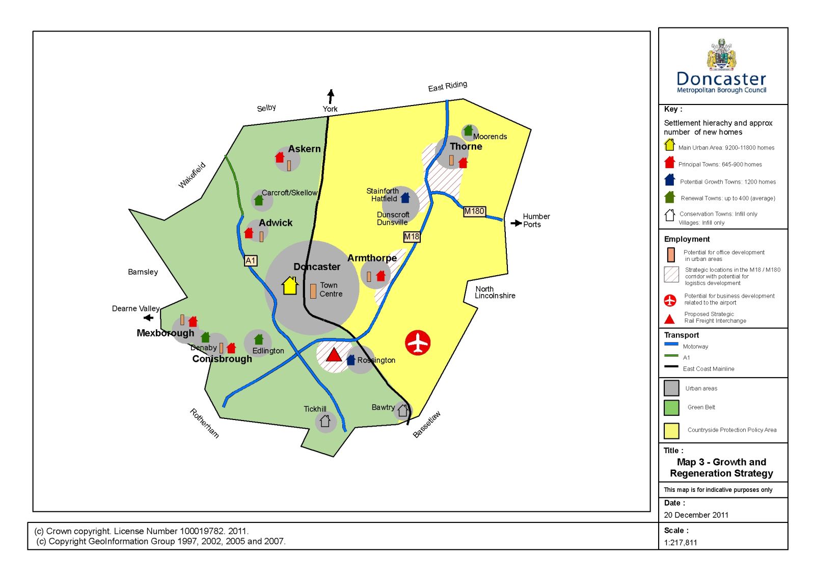
Map 3: Growth and Regeneration Strategy
Explanation
National policy seeks to build prosperous and sustainable communities by improving the economic performance of towns and cities, promoting regeneration and tackling deprivation. It seeks to focus development in existing centres accessible to public transport, jobs, key services and infrastructure so as to promote their vitality and viability, support town centre regeneration and minimise the need to travel. Land should be used efficiently and priority given to re-using well located brownfield land; natural resources, built and natural heritage should be conserved. The location of housing should support sustainable communities. Existing and expanding business sectors should be supported. The countryside should be protected; releases from the Green Belt require exceptional circumstances. Flood risk should be considered alongside other spatial planning issues.
At the sub-regional level, the Sheffield City Region Local Enterprise Partnership has been established, whose vision is, "for the Sheffield City Region to make a greater contribution to the UK economy by having a local economy less dependent on the public sector, providing conditions for business to grow and by giving the nation its prime centre for advanced manufacturing and materials and low carbon industries. We will offer people a great place in which to live, work, invest, and visit". The partnership proposal highlights various themes where action needs to be taken. These include issues such as creating more jobs, raising skill levels, unlocking the economic potential of key development areas, improving transport links, improving the housing offer and creating attractive city and town centres.
The South Yorkshire sub-regional centres (e.g. Doncaster) play an important part in driving economic growth but their ability to do this is hampered by a dispersed settlement pattern and unless this issue is resolved South Yorkshire will not be able to transform its economy and environment and address the problems of social disadvantage and exclusion. However, a balance must be achieved between this focus and the need to provide for growth and regeneration in the main outlying towns and recognition that there are some important opportunities for inward investment more closely associated with modern transport infrastructure than with historic settlement pattern. Therefore, an urban centric growth and urban transformation strategy is set out, with top priority to be the sub regional centres followed by the Principal Towns. Other settlements will need to meet locally generated needs for both market and affordable housing. Robin Hood Airport is a Regionally Significant Investment Priority, and is important to Doncaster's, and the wider Sheffield City Region's, growing logistics sector.
The South Yorkshire Settlement Study defined the extent of Doncaster's Main Urban Area and assessed its neighbourhoods and the outlying settlements in terms of their existing functional hierarchy, their potential for sustainable change and in terms of the benefits of accommodating sustainable growth and/or qualitative change (the key findings are summarised in Appendix 4). The Study took account of environmental constraints (including flooding), development opportunities, existing and proposed physical and social infrastructure and recognised that the most sustainable locations for growth would not in all cases reflect the existing functional hierarchy. The Strategic Housing Land Availability Assessment and Employment Land Review demonstrate that there is sufficient land that is developable and attractive to the market to deliver the proposed Growth and Regeneration Strategy (see Policies CS10 Housing, Requirement, Land Supply and Phasing and CS5: Employment Strategy for further information).
The policy seeks to distribute growth and regeneration where it would do most good in terms of supporting prosperous and sustainable communities by improving the economic performance of towns, promoting regeneration and tackling deprivation. It seeks to achieve a balance between a focus on Doncaster and sufficient growth and regeneration of the outlying towns. It proposes a growth distribution that does not always follow the existing functional hierarchy (notably the Potential Growth Towns and the Conservation Towns) and it supports important development opportunities associated with Doncaster's significant transport infrastructure which will have benefits for the whole of Doncaster and the wider sub-region.
The majority of housing growth (80-85%) will be directed to the Main Urban Area and Principal Towns. Significant growth will also be directed to the Potential Growth Towns, tied to delivery of proposed key infrastructure and significant local jobs creation. Elsewhere housing growth will be modest in order to achieve the urban concentration approach. In the Renewal Towns both the scale and timing of growth will be designed to support regeneration and housing renewal, whilst in the Conservation Towns and Larger Villages growth will be confined to infilling. The housing numbers will form the basis for identifying site allocations to accommodate 18,450 net additional homes (see Policy CS10: Housing, Requirement, Land Supply and Phasing).
Employment allocations will support the settlement hierarchy but must also take account of deliverability issues (i.e. the needs of business) and Doncaster's Economic Strategy; employment sites cannot always be located next to the communities they serve. The Local Economic Assessment stresses the need for Doncaster to concentrate on using its assets that give it comparative advantage to enable the economy to catch up with regional averages. This means exploiting the transport connectivity in Doncaster and its developable land alongside. However, priority will be given to sites within or adjacent to the Main Urban Area, Principal Towns and Potential Growth Towns where infrastructure can be brought forward; transport connectivity will be a priority to ensure there is access to jobs for all communities (see Policy CS5: Employment Strategy). Further development of the Airport and its business park is supported (see Policy CS6: Robin Hood Airport and Business Park) to support economic growth in the urban area and across all the borough and into the Sheffield City Region, including improved links to the strategic transport network.
Main town centre uses will be directed to the main centres in the retail hierarchy (see Policy CS7: Retail and Town Centres and CS8: Doncaster Town Centre). The centres and other service locations (e.g. hospitals, schools) will continue to provide a high proportion of jobs that will not have specific land allocations. The accessibility policies will ensure that such employment locations will be supported by public transport. Some limited service jobs will be permitted on employment allocations without detriment to their main function.
It is important that distinctive and vibrant local communities are maintained, and this will be achieved through improved services and improved access to services and by protecting the character of different parts of the borough. Local heritage assets will be protected and enhanced through the managed promotion of appropriate tourism, repair and restoration, high quality design and green infrastructure. Potential conflict with flood risk, Green Belt and other environmental constraints will be minimised as far as this is compatible with the strategy. Scenario testing work has been undertaken to ensure that the implications, particularly in relation to flood risk and Green Belt, are understood. This work indicates that whilst there is considerable urban potential in the Main Urban Area (mostly on brownfield sites that are well located and considered sustainable), much of this land is in Flood Zones 2/3. The alternative of not using these brownfield urban sites would require either large scale greenfield urban extensions (including land in Green Belt), or an allocation at the lower end of the growth range and a greater percentage of housing within the Principal Towns. Whilst at Armthorpe there is capacity to meet the upper-end of the growth range without using land in Green Belt or Flood Zones 2/3, this is in marked contrast to the other 5 Principal Towns where new urban extensions would require land in Green Belt and/or Flood Zone 2/3.
Main Urban Area
The Main Urban Area will be the main focus for growth and regeneration, with the quality and range of housing, employment and services improved for the benefit of the borough as a whole. This is well connected to national transport networks, including London, via the East Coast Main Line. It is the focus for much of the borough's employment opportunities and higher order services. The Town Centre is a shopping centre of regional significance and has seen a number of recent investments, including the Frenchgate Centre extension and Interchange.
The housing growth range recognises that too small an allocation would undermine the overall approach of locating development in sustainable locations and maximising the use of well located brownfield sites, whilst too large a housing allocation within the Main Urban Area would undermine the potential for growth and regeneration in other towns. There are major urban development opportunities notably those at Waterfront, Marshgate, Waterdale, Lakeside, Wheatley Hall Road, Hexthorpe and Edenthorpe; urban extensions are already planned at Manor Farm, Bessacarr and Woodfield Plantation, Balby. It is likely that there will need to be additional urban extensions (particularly if growth is at the top end of the growth range) with the main potential issues being Green Belt (west of the East Coast Main Line), flood risk (particularly along the River corridor and in Bentley), settlement coalescence (with Armthorpe), lack of brownfield opportunities and loss of countryside. Urban extensions are constrained elsewhere by Sites of Special Scientific Interest and important landscapes (including Potteric Carr, Sandall Beat Wood and Doncaster Common) and by physical barriers including the River Don and canal, railway lines and M18 and A1(M) motorways.
Doncaster Town Centre will also be the main location for retail and other key town centre uses, supported by the Local Retail Centres at Bentley, Intake, Balby, Edenthorpe and Woodfield Plantation. Furthermore, focussing office development on the town centre will aid clustering of a vibrant office sector, have a positive effect on town centre vibrancy and reduce car travel to less central locations. There are a number of sites close to or within the town centre that provide opportunities to meet the projected high quality office demand including Doncaster Waterfront, St Sepulchre Gate West, Civic and Cultural Quarter and Marshgate. It is also envisaged that the following sites will be retained for employment uses: Wheatley Hall Road (as part of mixed-use scheme); Shaw Lane; Kirk Sandall Industrial Estate; Doncaster and Balby Carr (including Lakeside).
Accessibility will be improved to existing and new jobs and the town centre from the rest of the borough with improved public transport and appropriate management of the type and amount of parking provision. Priorities include White Rose Way, M18, Woodfield Link Road, FARRRS, the Great Streets Scheme, St Sepulchre Gate West, Waterfront, Balby Island, Hyde Park and Lower Wheatley (see Policy CS9: Travel Choice and Table 8: Infrastructure Delivery Schedule).
The Principal Towns
These are proposed having regard to the Settlement Study, the Borough Strategy (and its objective of improving quality of life across the whole borough), urban development opportunities (including the four former collieries reclaimed as development platforms) and the distribution of environmental constraints to outward growth of towns (notably Green Belt and flood risk).
All currently function as high-middle order settlements. The market towns of Thorne and Mexborough have the largest town centres outside Doncaster and are important service centres for local catchments. The other four (former colliery) towns are reasonably self-sufficient in terms of day-to-day services and serve limited catchments (Askern is particularly important to its large rural catchment). All six Principal Towns would derive high potential benefits from growth and qualitative change; all have good opportunities for sustainable development. All except Armthorpe are the subject of current housing renewal initiatives. All but Armthorpe and Askern have rail stations; Askern will require improvements to bus services tied to new development opportunities.
The Principal Towns housing growth range will support market-led housing growth and service improvements provided a minimum requirement consistent with the lower end of the range is allocated to each town. Urban extensions will be necessary to accommodate the proposed growth (even at the lower end of the growth range) at Adwick, Armthorpe, Askern and Thorne but may not be necessary at Mexborough and Conisbrough (where more brownfield urban sites exist) unless the allocations for these towns are towards the top end of the growth range. Any urban extensions at Adwick, Mexborough and Conisbrough would require loss of Green Belt, whilst any extensions at Thorne will require land in Flood Zone 3. Thorne and Mexborough Town Centres and Adwick, Armthorpe, Askern, Conisbrough District centres will be protected and enhanced. Locally appropriate town centre uses will be supported primarily in Thorne and Mexborough town centres but District Centre proposals must be of an appropriate nature and scale. Locally appropriate office uses will be supported in Thorne and Mexborough and are unlikely to be appropriate in the District Centres.
The plan provides for the retention and creation of a range of employment sites across the borough to support business growth and maximise local communities' employment opportunities (see Policy CS5: Employment Strategy). It is envisaged that these will include existing sites at Carcroft Common, close to Askern, Adwick and Bentley and at Redhouse, within the A1(M) corridor. Whilst an extension to Carcroft Common could be accommodated without loss of Green Belt (on the existing Bentley Moor Lane Unitary Development Plan allocation), it is acknowledged that there may need to be some loss of Green Belt at Adwick to accommodate local opportunities (see Policy CS3: Countryside). Within the M18/M180 corridor a number of opportunities exist associated with the strategic transport network at the junctions near to Armthorpe and Thorne. Improvements to public transport connectivity to the Main Urban Area and wider opportunities will be supported, as will improvements to access for pedestrians and cyclists. In addition, the transport policies will support improving accessibility to employment sites from across the borough.
The Potential Growth Towns
These are large colliery/former colliery settlements in need of physical and economic regeneration. They function as low-middle order settlements but have been identified as having high potential benefits from change. Whilst housing renewal and physical regeneration of the Local Retail Centres is important, successful regeneration will also require significant growth. Both lie alongside the M18 but have poor access to it and presently derive little or no benefit from ongoing and planned investment along this corridor. However, major economic investment site opportunities have been identified (tied in part to proposed improved access to the M18) that would transform the economic prospects of these towns and require new housing to serve the new jobs. At Stainforth/Hatfield this is the DN7 project, which involves a mix of uses based around the Hatfield Colliery and the Planning Permissions for: the development of a Power Park, including a new Power Station; the delivery of a new Link Road to the M18; new employment uses, including (potentially rail served) distribution facilities; the creation of a new Marina and associated public open space and managed nature conservation. The use of engineered colliery spoil has the potential to facilitate this large-scale mix of uses, including the potential for associated housing growth, through the creation of development platforms and the mitigation of flood risk. At Rossington, a Strategic Rail Freight Interchange is proposed along with the FARRRS and the reclamation of the former colliery for housing.
In both settlements, the retention of existing employment opportunities (at Bankwood Lane, Rossington and Bootham Lane, Hatfield) will also be supported. The existing Local Retail Centres of Rossington, Hatfield, Stainforth and Dunscroft will be protected and enhanced, and the provision of an improved range and quality of retail and community facilities will be supported. At Stainforth/Hatfield the provision of new community facilities will be supported within or adjoining the new housing to provide benefits for all four settlements.
Subsequent Development Plan Documents (and/or Supplementary Planning Documents) will set out detail on the principles and site specific criteria for these developments. However it is envisaged that at Rossington housing growth will be subject to the co-ordinated delivery of:
- FARRRS;
- Rossington Strategic Rail Freight interchange; and
- improvements to existing housing areas and the Local Retail Centre.
Similarly, it is envisaged that at Stainforth/Hatfield housing growth will be co-ordinated/phased with the delivery of:
- jobs and infrastructure including Hatfield Power Park and power station and M18 link road;
- improvements to existing housing areas and Local Retail Centres;
- refurbishment of the railway station and the creation of a rail/bus/park and ride interchange; and;
- suitable flood risk mitigation.
In both cases there are also opportunities within the existing settlement boundaries including those arising from housing renewal/urban remodelling which may provide improved or additional housing.
The principle and timing of the housing will be dependent upon delivery of the proposed infrastructure and jobs, and should these not happen then housing growth on the scale proposed may not be supported. However, it is envisaged that these will be able to proceed together in a co-ordinated way within a clearly deliverable framework (such as a Neighbourhood Plan and/or a planning application(s) subject to phasing conditions, legal agreement and funding contributions plan). Within this context, 1200 housing units for each of the Potential Growth Towns is a credible plan period allocation, and it is recognised that the projects in each of these settlements could continue to deliver further housing and economic growth beyond the plan period, consistent with their eventual re-designation as Principal Towns through a review of the Core Strategy.
The Renewal Towns
These are all Local Retail Centres. Carcroft/Skellow and Edlington function as middle-high order settlements but are served by Adwick and Mexborough/Doncaster respectively. Denaby and Moorends function as low-middle order settlements and are served by Mexborough/Conisbrough and Thorne respectively as well as by Doncaster. The potential benefits from change identified are low for Carcroft/Skellow and high for the others but with an emphasis in all four towns on qualitative change (housing renewal, improvements to district retail centres etc.) rather than outward growth. Edlington and Denaby lie within Pathfinder where master-planned renewal schemes including some urban remodelling are under way or programmed. Carcroft/Skellow lies within the Green Corridor housing renewal initiative. The need for housing renewal and regeneration has also been identified in Moorends.
Renewal is therefore the priority in all four towns and this could be undermined (particularly in the short-medium term) by large urban extensions whilst more sustainable opportunities for market-led growth have been identified elsewhere in the borough. For these reasons the scale of the overall allocation (up to 9%) and the distribution of this between the towns (unspecified) are flexible so that it can be informed by site sustainability considerations. The Local Retail Centres of Edlington, Moorends and Carcroft will be protected and enhanced.
Existing business estates such as Broomhouse Lane, Warmsworth Holt and Denaby Lane will be retained and, where appropriate, expanded (although in some cases, such as at Denaby, this may require the release of smaller Green Belt sites). However, as new sectors are attracted elsewhere, improved transport links will be a priority between the Renewal Towns and strategic employment areas and Doncaster urban centre.
The Conservation Towns
These function as high-middle order settlements but have been identified as having low benefits from change. They are both attractive market towns with high quality historic (conservation area) centres containing a good range of services that serve wider catchments. Both, however, are also surrounded by extensive suburban developments and are constrained from further outward growth by Green Belt and, in the case of Bawtry, by the East Coast Main Line and a Site of Special Scientific Interest. New development on the edge of these towns would further erode their historic character, increase car journeys into their centres and increase outward commuting; the towns are relatively poor in terms of public transport accessibility. New housing will therefore be limited to quality infill within existing settlement boundaries. The District Centres of Bawtry and Tickhill will be protected and enhanced and appropriate employment opportunities will be within existing employment sites and town centres and through transport links to urban areas.
The Larger (Defined) Villages
These are mostly attractive and popular places to live. However, they are relatively unsustainable locations for future housing growth. All function as low order settlements except Barnby Dun (low-middle order) and none are identified as having any potential benefits from change. Therefore, only quality infill within existing settlement boundaries, including affordable housing will be supported. Small-scale affordable housing in accordance with the rural exceptions policy will also be supported. Proposals involving the loss of existing shops, pubs or other local services, will be required to demonstrate that all reasonable attempts have been made to retain the service or to secure an alternative local facility in its place. Job opportunities will be provided through transport links to urban areas in the surrounding rural economy and in appropriate small scale business premises. Public transport accessibility criteria will be met, including supporting connectivity to service centres.
The Smaller (Undefined) Villages
These comprise loosely defined villages and hamlets that have been historically washed over by what is currently Green Belt or Countryside Policy Area designations and this will be continued (with the latter becoming Countryside Protection Policy Area - see Policy CS3). They are unsustainable locations for new housing, and so new dwellings will be confined to agricultural dwellings, replacement dwellings and, exceptionally, conversions of suitable rural buildings. However, appropriate rural diversification schemes will be supported (see Policy CS3).
Policy CS3 – Countryside
Doncaster's countryside will be protected and enhanced, having regard to the principles set out below.
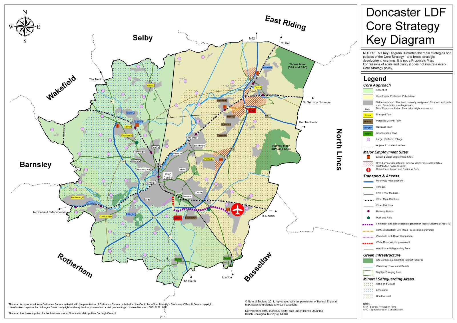
A) The general extent of the Green Belt will be retained (as indicated on the Key Diagram). The key considerations for land within this area are:
- national policy will be applied, including a presumption against inappropriate development other than in very special circumstances; and;
- land will only be taken out of the Green Belt for development allocations in exceptional circumstances for example where necessary to sustainably deliver the Growth and Regeneration Strategy.
B) The countryside in the east of the borough will continue to be protected through a Countryside Protection Policy Area (as indicated on the Key Diagram). The key considerations for land within this area are:
- new urban extension development allocations will be confined to those necessary to deliver the Growth and Regeneration Strategy;
- minor amendments to settlement boundaries will be supported where existing boundaries are indefensible;
- proposals will be supported where they would be appropriate to a countryside location and would protect and enhance the countryside for the sake of its intrinsic character and beauty, the diversity of its landscapes, heritage and wildlife, the wealth of its natural resources and to ensure it may be enjoyed by all; and;
- proposals that would generally be acceptable include agriculture, forestry, outdoor sport and recreation, habitat creation, flood storage and management, essential infrastructure, mineral extraction, some forms of stand alone renewable energy, suitable farm diversification schemes, limited extension, alteration or replacement of existing dwellings and re-use of suitable buildings for uses appropriate in the countryside.
C) Proposals which are outside development allocations will only be supported where they would:
- protect and enhance the countryside, including the retention and improvement of key green wedges where areas of countryside fulfil a variety of key functions;
- not be visually detrimental by reason of siting, materials or design;
- not create or aggravate highway or amenity problems; and;
- preserve the openness of the Green Belt and Countryside Protection Policy Area and not conflict with the purposes of including land within them.
D) Although not required to deliver the Growth and Regeneration Strategy set out in Policy CS2, the extent of the Green Belt will be reviewed to inform future versions of the Core Strategy.
Explanation
National policy states that once the general extent of a Green Belt has been established it should be altered only in exceptional circumstances; similarly detailed boundaries defined in earlier plans such as the Unitary Development Plan should be altered only exceptionally. The general policies controlling development in the countryside apply with equal force in the Green Belt but there is in addition a general presumption against inappropriate development within them and such proposals should not be approved except in very special circumstances. The countryside has the potential to provide a variety of functions, including preventing the merging of settlements as well as wider environmental and leisure benefits (as set out in more detail in Policy CS17 - Green Infrastructure).
As shown on the Key Diagram, Doncaster's countryside in the western 'half' of the borough forms part of the South Yorkshire Green Belt the purpose of which is to prevent the merging of large neighbouring metropolitan urban areas (Doncaster, Rotherham, Barnsley, Wakefield); its detailed boundaries were established through the Unitary Development Plan in 1998 and will continue to be protected in accordance with national planning policy. The countryside in the eastern 'half' of Doncaster does not meet the purposes of the South Yorkshire Green Belt but is otherwise just as valuable and this is reflected in the Countryside Protection Policy Area designation and the development management policies, which apply here.
The Growth and Regeneration Strategy can be delivered without altering the general extent of the Green Belt within Doncaster as development allocations involving Green Belt are expected to be very limited. However, it is possible that Green Belt sites may be more sustainable than non-Green Belt alternatives but the consideration of alterative sites will be across the Main Doncaster Urban Area and all the Principal Towns so that precise allocations to each town within the growth ranges can address a number of objectives including minimising the loss of Green Belt. This conforms with current regional policy, which states that the general extent of the South Yorkshire Green Belt should not be changed but that localised reviews of Green Belt boundaries may be necessary in some places to deliver the core approach and sub area policies.
The outer boundaries of existing built up areas where they adjoin countryside are under constant pressure for often minor but cumulatively significant adjustments, usually to facilitate small scale housing developments. It is important to ensure that the countryside is not eroded in this way. This sort of amendment will therefore be exceptional in nature and will only be made where the existing boundary is no longer defensible. However, if the ambitious Growth and Regeneration Strategy set out within Policy CS2 is realised, it may mean that future versions of the Core Strategy are faced with different issues, challenges and opportunities (including the possible re-designation of Hatfield/Stainforth and Rossington as Principal Towns). It is therefore considered appropriate for a full review of the Green Belt to inform the next version of the Core Strategy.
Urban extensions on land previously designated Countryside Policy Area, will be required to meet the borough's housing and employment requirement, but these will be minimised through a strategy promoting urban sites.
Policy CS4 – Flooding and Drainage
Large areas of Doncaster are at risk of flooding. However, many of these areas already benefit from defences and are otherwise sustainable locations for growth. A pro-active approach will therefore be adopted which manages flood risk, to support borough-wide regeneration, based on the principles set out below.
A) Development will be directed to areas of lowest flood risk (from all sources) within the overall framework of the Growth and Regeneration Strategy and its emphasis on deliverable urban brownfield sites (as set out in Policies CS2, CS5, CS7 and CS10). Where this results in development within flood zones 2 and 3, priority will be given to sites which:
- already benefit from an acceptable standard and condition of defences; or;
- have existing defences which will be improved as a result of the proposal to an acceptable standard and condition; or;
- do not have existing defences, if it can be shown that there are no appropriate sites already benefiting from defences, and the development can be made safe through the creation of new defences which would also benefit existing communities.
B) Developments within flood risk areas will be supported where they pass the Sequential and/or Exception Tests (if they are required). Proposals which are in accordance with both allocations and any other Local Development Framework policies will normally be deemed to have passed the Sequential Test.
C) All development over 1 hectare, and any development within flood risk areas, will be supported where it:
- provides a fit-for-purpose site specific Flood Risk Assessment;
- will be safe from all forms of flooding, without increasing the level of flood risk to surrounding properties and/or land for the lifetime of the development;
- provides adequate means of foul sewage disposal and achieves a reduction in surface water run off on brownfield sites and no increase from existing rates on greenfield sites;
- makes use of Sustainable Drainage Schemes, where appropriate;
- is designed to be resilient to any flooding which may occur (including making provision for circumstances in which existing flood defences fail);
- facilitates the maintenance of flooding and drainage infrastructure; and;
- ensures that mitigation measures (including Sustainable Drainage Schemes) can be maintained over the long term and will not have an adverse impact on the water environment, including ground water aquifers, flood water capacity and nature conservation interests.
Explanation
Climate change from extreme weather events, rising sea levels and surface water run off from future development will exacerbate the threat of flooding on people, land and property in the borough (much of which lies below sea-level) over the coming years. Under the Flood and Water Management Act 2010, Doncaster Council will be the designated Lead Local Flood Authority for the borough, and so develop, maintain, apply and monitor a strategy for local flood risk management within the local area. The council is committed to continued partnership working with bodies such as the Environment Agency, Internal Drainage Boards and water companies, as part of a multi-agency response to managing flooding issues across the borough.
There are four types of flood zone for river and coastal flooding, as summarised below. Zones 1 - 3a are identified on the Environment Agency's flood zone maps, whilst 3b is identified by the Local Authority in consultation with the Environment Agency.
- Zone 1: low probability of flooding (less than a 1 in 1000 year / 0.1% risk of flooding).
- Zone 2: medium probability (between 1 in 100 year / 1.0% chance and 1 in 1000 year / 0.1% chance of flooding).
- Zone 3a: high probability (greater than 1 in 100 year / 1.0% or greater chance of flooding.
- Zone 3b: functional floodplain.
These zones are based on probability not risk - with risk being the combination of the probability of flooding with the potential impact of any flood event (e.g. what might be flooded, the depth of flooding etc.). Furthermore, there are other forms of flooding which these maps do not show - for example surface water and groundwater flooding. It is important that the planning process considers the overall risk from all sources of flooding. Therefore, for the purposes of this policy, flood risk areas include flood zones 2 and 3, areas with known surface water drainage difficulties and areas with known groundwater flooding Issues.
National policy requires a sequential approach to steer development away from flood risk areas and to manage and reduce overall flood risk. This means that where proposals (either site allocations within the Local Development Framework or individual planning applications) are proposed within flood risk areas, evidence must be provided to demonstrate that these proposals could not take place in areas which are at lower risk. In Doncaster, flooding comes from a number of sources, including the rivers Don and Dearne in the west and the rivers Torne and Trent in the south and the watercourses that feed to them, plus tidal flooding within the low lying Humberhead Levels. As Map 4 shows, the flood risk areas are extensive.
The Growth and Regeneration Strategy set out in Policy CS2 proposes growth that will require significant development within flood risk areas, particularly along the M18 motorway corridor, Thorne, Hatfield/Stainforth and parts of Doncaster Main Urban Area, where there are significant regeneration and redevelopment opportunities. This is to ensure that we achieve borough-wide regeneration and take account of wider national policy which seeks to direct growth to urban areas, deliver sufficient housing and jobs and to address issues of deprivation. The challenge is therefore to provide sufficient growth and opportunities to regenerate deprived communities, including those within flood risk areas, without undermining efforts to combat climate change and flood risk.
The policy indicates that development will be directed to areas at lowest risk within the overall framework of the Growth and Regeneration Strategy set out in Policy CS2. In making site allocations, the sequential test will therefore be applied within this wider policy context. Sites which are allocated within the Proposals Map will not then require a sequential test at the planning application stage (although the layout should have regard to different levels of flood risk across the site and take a sequential approach to layout). Proposals on sites which are not included within the Proposals Map will normally need to carry out a sequential test at the planning application stage, in accordance with national policy and Doncaster's Development and Flood Risk Supplementary Planning Document (see paragraph 3.44), and this should have regard to the need to provide sufficient land to meet local needs in line with the wider policy framework.
The policy also sets out how appropriate provisions will be put in place to manage and reduce flood risks associated with both new and existing development within flood risk areas. It is important that new developments are made safe (including, where appropriate, resilient to any flooding which may occur and that the residual risk of breach and/or overtopping of any defences does not pose significant danger to people and/or property) and that they do not increase the likelihood or impact of flooding on surrounding properties. As part of this, proposals on brownfield sites will be supported which achieve a reduction in surface water run off. We will look for a reduction of 30% on brownfield sites, but will consider each case on its merits having regard to what is practical. The policy supports sustainable drainage schemes (SuDS), although careful consideration of the various techniques will be required in order to take account of potential land contamination or groundwater sensitivities. The policy also requires proposals to facilitate the maintenance of flooding and drainage infrastructure. This includes such measures as retaining appropriate buffer strips to all watercourses (excluding canals), to ensure that flood defences and access can be maintained, and avoiding the culverting or building over of watercourses (unless it is essential to facilitate access). Canals are not part of flood defence infrastructure and levels are carefully regulated by weirs, sluices and other infrastructure which are maintained from the canal itself, or towpath, and as such they do not require a buffer strip to be retained for flood defence maintenance and access.
The policy seeks to protect and increase the capacity of the functional floodplain (otherwise known as washland) to store water during times of flood and thus protect other areas from flooding and habitats. In the functional flood plain, only water compatible uses (e.g. open space and outdoor recreation facilities, wetland habitat creation schemes etc.) essential transport or utility infrastructure can take place provided they pass the exception test. It will be necessary to consider the issue of bird strike in the interests of air safety within the vicinity of Robin Hood Airport. Advice regarding bird strike and airports (currently CAP772 Civil Aviation Authority 2007) indicates that bird strike hazard in the vicinity of the airport should be taken to be land or water within 13 kilometres of the airfield and the airport authority is consulted on any proposals for wetland creation within this area.
The council has adopted a Development and Flood Risk Supplementary Planning Document which provides more detailed guidance for developers submitting planning applications in relation to flood risk and drainage. It sets out the forms of development which will be considered to automatically pass the sequential test, the requirements in terms of windfall sites and also advises on the type of information to be included within individual Flood Risk Assessments (which should reference the most up-to-date information as well as Doncaster's Strategic Flood Risk Assessment). Furthermore, any flood and drainage works within the vicinity of Thorne and Hatfield Moors will need to ensure that they do not adversely impact on the water levels within the site (and so consider the need for a Habitats Regulation Assessment).
Map 4: Flooding